| About IVS | Observing Program | Network Stations | Data&Products | Analysis | Technology | Publications | Meetings |
|
2024 Master File Links
Guidelines
Observing Tasks
|
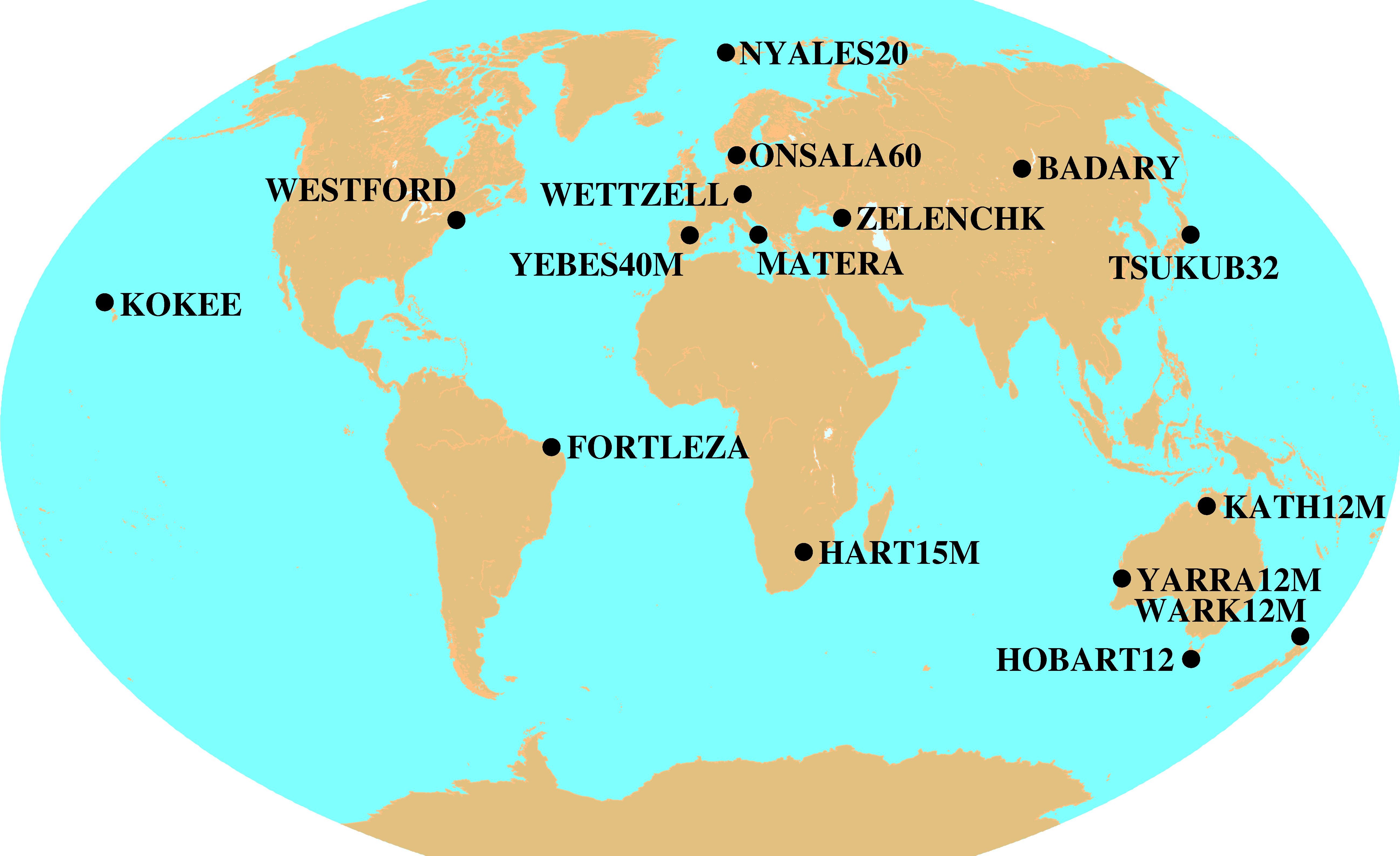
Observing ProgramCONT14Continuous VLBI Campaign 2014This Web page will undergo frequent updates as the planning of the CONT14 campaign progresses. Please send a message to the Coordinating Center if you have updates or links to be included on this page. PurposeCONT14 is a campaign of continuous VLBI sessions, scheduled to be observed in the early May 2014 (6-MAY-2014 00:00 UT through 20-MAY-2014 24:00 UT). The CONT14 campaign will be a continuation of the series of very successful continuous VLBI campaigns that were observed at irregular intervals since 1994. The most recent CONT campaigns were observed in roughly three-year intervals as CONT05 (September 2005), and CONT08 (August 2008), and CONT11 (September 2001). With a network size of seventeen stations (ten in the northern hemisphere and seven in the southern hemisphere) at sixteen sites the observation mode will depend on the station capabilities, media resources, e-transfer capacities, and correlator resources. Resource limitations may make it necessary to reduce the network size or length of the campaign. GoalsThe plan for the CONT14 campaign is to acquire state-of-the-art VLBI data over a time period of about two weeks to demonstrate the highest accuracy of which the current VLBI system is capable. This will support high resolution Earth rotation studies, investigations of reference frame stability, and investigations of daily to sub-daily site motions, among other things. A number of scientific and technical goals are set for the campaign:
Observation PeriodThe fifteen days of continuous VLBI observation have been fixed as follows:
Network ResourcesThe following network resources will be used during the CONT14 campaign:
Station TestingIn order to make sure the stations are in good operating condition before CONT14, a set of tests is being developed under the direction of Brian Corey and Ed Himwich for each station to perform. These tests will be based on the similar tests that were done for previous CONT experiments, the last of which was the CONT11 campaign in 2011. Correlator ResourcesWith a network size of seventeen stations, the CONT14 campaign can be viewed as a precursor of the observing mode of the next generation VLBI system (VGOS). In VGOS mode networks of sixteen or more stations will observe continuously and transfer their data to a correlator facility for immediate correlation so that results become available within 24 hours of the end of observation. The completion requirements for CONT14 are less stringent than for VGOS. It is expected that recording modules will store several campaign days of a given station in order to optimize the usage of media. Hence, for logistical ease, consistency of results, and to gain experience in VGOS-type load, correlation will be performed at a single correlator. The Bonn Correlator will take on the large task of correlating the CONT14 data. Expected AccuraciesThe schedule will be a standard geodetic schedule which achieves simulated EOP results of at least as good as 35 µarcsec for pole position and 1.5 µs for UT1. The recording mode will probably be the 2-bit sampled version of the R1 mode (512 Mb/s data rate) which was successfully used in the previous two CONT campaigns. SchedulesThe detailed observing schedule for CONT14 will be generated using the automatic scheduling algorithms of the NASA sked program. We will investigate the best combination of scheduling parameters, minimum SNR levels, source list, and flux models. The best schedule will be determined as a compromise between the optimum simulated formal errors, number of observations, number of scans per hour, sky coverage, and robustness. Gaps with no observational data will be avoided by scheduling the daily station checks at non-overlapping, staggered time periods that are convenient for the stations. Ultra-rapid dUT1 DeterminationFor the length of the CONT14 campaign an ultra-rapid dUT1 determination will be performed on the basaline between Onsala and Tsukuba. The data will be e-transferred to the Tsukuba correlator, correlated, and analyzed in near real-time so that dUT1 estimates are available about 1 hour after the observation. More information is compiled in a dedicated Web page at GSI. |
| Back to Top Last Updated: |